
Morphometric parameters and the limnological status of the Calima reservoir, Valle del Cauca, Colombia

Article Sidebar
Main Article Content
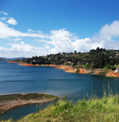
Introduction: The bathymetry of the Calima Reservoir has changed considerably since its construction, as evidenced by the loss of useful volume, reduced depth, and morphological alterations caused by sediment accumulation in the tail waters and changes in terrestrial biotopes associated with the water surface.
Objective: To determine the bathymetric structure of the reservoir in 2023 and identify the spatial domains most affected by the entry of contaminants that may promote the growth of algae and cyanobacteria, potentially compromising the use of the water for recreation, aquatic sports, and sport fishing.
Methodology: In April 2023, a bathymetric profile was surveyed in a zigzag pattern across the reservoir using an echosounder with a transducer and GPS. The field data were organized in Excel and integrated into ArcGIS Pro 3.1.3 to generate the bathymetric layout and calculate physical parameters.
Results: Three zones were defined. Zone A: the main deposition area at the inlet of the Calima River, containing the shallowest isolines; two streams converge here, carrying most of the wastewater from the municipality of Calima El Darién, where algal blooms have been reported. Zone B: a narrow strip with depths ranging from 40 to 60 m. Zone C: the dam area, with depths close to 70 m.
Conclusions: The reservoir has an elongated shape aligned with the flow axis of the Calima River. Upon entering, the river loses horizontal energy and deposits suspended solids, forming a lentic zone that narrows toward the dam. The dendritic zones remain isolated from the main axis, and Zone A receives the highest load of urban discharges, favoring the proliferation of phytoplanktonic algae.
- Reservoir
- bathymetric map
- morphometric parameters
- water resources
(1) Roldán G, Ramírez JJ. Fundamentos de limnología neotropical. 3ra ed. Medellín: Academia
Colombiana de Ciencias Exactas, Físicas y Naturales; 2022. ISBN 978 958 52969 0 9.
(2) Margalef R. Ecología, 9na ed. Barcelona: Ediciones Omega;1998. ISBN: 978-84-282-0405-7
(3) Montoya Y, Vélez F, Aguirre N. Características morfométricas de un lago de plano inundable
tropical (ciénaga Hoyo Los Bagres, Colombia). Rev. Fac. Ing. 2011; 59:203-214. https://revistas.udea.
edu.co/index.php/ingenieria/article/view/13825
(4) Sjöberg Y, Dessirier B, Ghajarnia N, Jaramillo F, Jarsjö J, Panahi D, Xu D, Zou L, Manzoni S.
Scaling relations reveal global and regional differences in morphometry of reservoirs and natural
lakes. Sci. Total Environ. 2022; 822:153510. https://doi.org/10.1016/j.scitotenv.2022.153510
(5) Pereira Júnior A, Morales G, Beltrão N, Pontes A. Application of bathymetry in water bodies
in urban areas of the five Brazilian regions. Rev. Cient. Multidisciplinar Núcleo do Conhecimento.
; 02:104-138. https://doi.10.32749/nucleodoconhecimento.com.br/environmentalengineering-
en/application-of-bathymetry
(6)Van Der Wal D, Pye K. The use of historical bathymetric charts in a GIS to assess morphological
change in estuaries. Geogr. J. 2003; 169(1):21–31. https://www.jstor.org/stable/3451537
(7) Wita P, Szafraniec JE, Absalon D, Woźnica A. Lake bottom relief reconstruction and water volume
estimation based on the subsidence rate of the post-mining area (Bytom, Southern Poland). Sci.
Rep. 2024; 14:5230. https://doi.org/10.1038/s41598-024-55963-0
(8) Rivera-Rondón CA, Zapata ÁM, Rondón JCD. Morphometric study of Lake Guatavita (Colombia).
Acta Biol. Colomb. 2010; 15(3):131-144. http://hdl.handle.net/10261/56590
(9) García-Rentería F, González-Chirino M. Effect of bathymetric changes on residence time
in Buenaventura bay (Colombia). Dyna. 2019;86(211): 241-248. htpps://doi.10.15446/dyna.
v86n211.79649
(10) Yin Y, Peng S, Ding X. Multi-scale response relationship between water quality of rivers
entering lakes from different pollution source areas and land use intensity: a case study of the
three lakes in central Yunnan. Environ. Sci. Pollut. Res. Int. 2024; 31(7):11010-11025. https://doi.
org/10.1007/s11356-023-31506-4
(11) Narayanan A, Cohen S, Gardner JR. Riverine sediment response to deforestation in the Amazon
basin. Earth Surf. Dyn.2024;12(2):581–599. https://doi.org/10.5194/esurf-12-581-2024
(12) Ariza Ortiz A, Roa Melgarejo O, Serrato P, León H. Uso de índices espectrales derivados
de sensores remotos para la caracterización geomorfológica en zonas insulares del Caribe
colombiano. Perspect. Geog. 2018;23(1):105-122. https://doi.10.19053/01233769.5863
(13) Rodrigo, C. Caracterización y clasificación de la bahía de Puerto Montt mediante batimetría
de multihaz y datos de backscatter. Lat. Am. J. Aquat. Res. 2006; 34(1): 83-94. http://dx.doi.
org/10.4067/S0717-71782006000100007
(14) Carreño F, López I, Payán J, Arranz C, Castellanos E. Aplicación del análisis textural a datos de
retrodispersión de sonda multihaz para la clasificación de fondos marinos. Revista de teledetección.
;36:5-19. https://dialnet.unirioja.es/metricas/documentos/ARTREV/3846354
(15) Maestri M. Modelos matemáticos y computacionales para el análisis de la dinámica ecológica
de las lagunas de la región pampeana. Tesis de Centro Científico tecnológico CONICET - TANDIL
http://hdl.handle.net/11336/111723
(16) Monteoliva A, Schneider P. Aplicación de un nuevo método para la evaluación censal de
la ictiofauna de embalses: hidroacústica digital con haz vertical y horizontal. Limnetica. 2005;
(1):161-170. https://doi. 10.23818/limn.24.16
(17) Arruebo T. Valoración integral de los lagos glaciares del Pirineo aragonés: una propuesta
para su gestión. Tesis doctoral Universidad de Zaragoza. 2014. https://dialnet.unirioja.es/servlet/
tesis?codigo=203702
(18) Fabián Roland J. Diversidad, composición funcional y estructura de tamaños del plancton en un
sistema eutrófico y otro hipereutrófico: Las albuferas de Adra (Almería). Tesis doctoral Universidad
de Granada. 2002. https://dialnet.unirioja.es/servlet/tesis?codigo=143014
(19) L. Pineda-Alarcón, J. E. Cañón Barriga. Modelación de la relación predador-presa para la
comunidad de macroinvertebrados en el litoral del lago de Tota. Acta Bio. Colomb. 2024;28(2):189-
https://doi.org/10.15446/abc.v28n2.97983
(20) Wetzel G, Likens G. Limnological analyses, 3rd ed. New York: Springer Verlag; 2000. ISBN 0-387-
-5.
Downloads


This work is licensed under a Creative Commons Attribution-NonCommercial-ShareAlike 4.0 International License.
Authors grant the journal and Universidad del Valle the economic rights over accepted manuscripts, but may make any reuse they deem appropriate for professional, educational, academic or scientific reasons, in accordance with the terms of the license granted by the journal to all its articles.
Articles will be published under the Creative Commons 4.0 BY-NC-SA licence (Attribution-NonCommercial-ShareAlike).